| diagram | 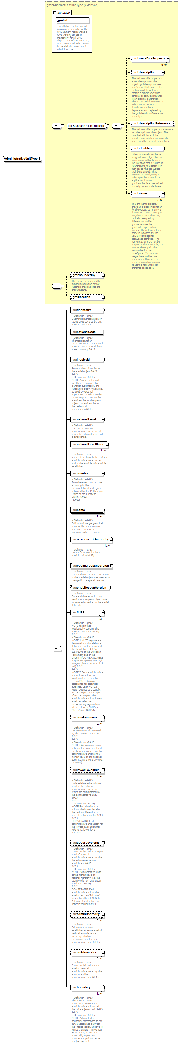 |
||||||||||||||
| namespace | urn:x-inspire:specification:gmlas:AdministrativeUnits:3.0 | ||||||||||||||
| type | extension of gml:AbstractFeatureType | ||||||||||||||
| properties |
|
||||||||||||||
| children | gml:metaDataProperty gml:description gml:descriptionReference gml:identifier gml:name gml:boundedBy gml:location au:geometry au:nationalCode au:inspireId au:nationalLevel au:nationalLevelName au:country au:name au:residenceOfAuthority au:beginLifespanVersion au:endLifespanVersion au:NUTS au:condominium au:lowerLevelUnit au:upperLevelUnit au:administeredBy au:coAdminister au:boundary | ||||||||||||||
| attributes |
|
element AdministrativeUnitType/geometry
| diagram | 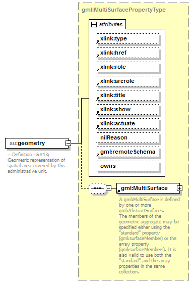 |
||||||||||||||||||||||||||||||||||||||||||||||||||||||||||||||||||||
| namespace | urn:x-inspire:specification:gmlas:AdministrativeUnits:3.0 | ||||||||||||||||||||||||||||||||||||||||||||||||||||||||||||||||||||
| type | gml:MultiSurfacePropertyType | ||||||||||||||||||||||||||||||||||||||||||||||||||||||||||||||||||||
| properties |
|
||||||||||||||||||||||||||||||||||||||||||||||||||||||||||||||||||||
| children | gml:MultiSurface | ||||||||||||||||||||||||||||||||||||||||||||||||||||||||||||||||||||
| attributes |
|
||||||||||||||||||||||||||||||||||||||||||||||||||||||||||||||||||||
| annotation |
|
element AdministrativeUnitType/nationalCode
| diagram | 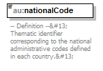 |
||||
| namespace | urn:x-inspire:specification:gmlas:AdministrativeUnits:3.0 | ||||
| type | string | ||||
| properties |
|
||||
| annotation |
|
element AdministrativeUnitType/inspireId
| diagram | 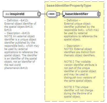 |
||||
| namespace | urn:x-inspire:specification:gmlas:AdministrativeUnits:3.0 | ||||
| type | base:IdentifierPropertyType | ||||
| properties |
|
||||
| children | base:Identifier | ||||
| annotation |
|
element AdministrativeUnitType/nationalLevel
| diagram | 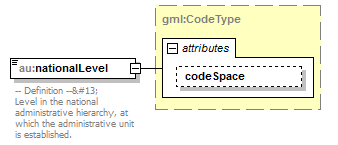 |
||||||||||||
| namespace | urn:x-inspire:specification:gmlas:AdministrativeUnits:3.0 | ||||||||||||
| type | gml:CodeType | ||||||||||||
| properties |
|
||||||||||||
| attributes |
|
||||||||||||
| annotation |
|
element AdministrativeUnitType/nationalLevelName
| diagram | 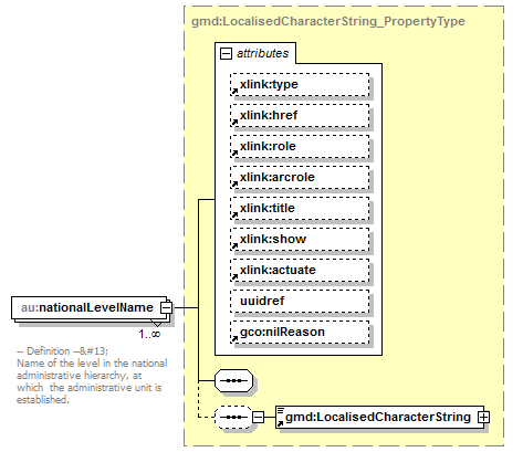 |
||||||||||||||||||||||||||||||||||||||||||||||||||||||||||||
| namespace | urn:x-inspire:specification:gmlas:AdministrativeUnits:3.0 | ||||||||||||||||||||||||||||||||||||||||||||||||||||||||||||
| type | gmd:LocalisedCharacterString_PropertyType | ||||||||||||||||||||||||||||||||||||||||||||||||||||||||||||
| properties |
|
||||||||||||||||||||||||||||||||||||||||||||||||||||||||||||
| children | gmd:LocalisedCharacterString | ||||||||||||||||||||||||||||||||||||||||||||||||||||||||||||
| attributes |
|
||||||||||||||||||||||||||||||||||||||||||||||||||||||||||||
| annotation |
|
element AdministrativeUnitType/country
| diagram | 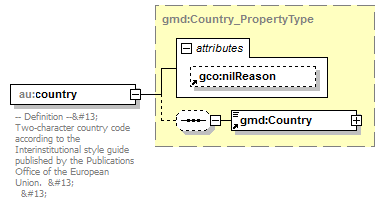 |
||||||||||||
| namespace | urn:x-inspire:specification:gmlas:AdministrativeUnits:3.0 | ||||||||||||
| type | gmd:Country_PropertyType | ||||||||||||
| properties |
|
||||||||||||
| children | gmd:Country | ||||||||||||
| attributes |
|
||||||||||||
| annotation |
|
element AdministrativeUnitType/name
| diagram | 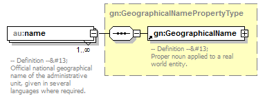 |
||||||||
| namespace | urn:x-inspire:specification:gmlas:AdministrativeUnits:3.0 | ||||||||
| type | gn:GeographicalNamePropertyType | ||||||||
| properties |
|
||||||||
| children | gn:GeographicalName | ||||||||
| annotation |
|
element AdministrativeUnitType/residenceOfAuthority
| diagram | 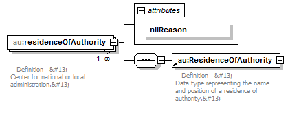 |
||||||||||||
| namespace | urn:x-inspire:specification:gmlas:AdministrativeUnits:3.0 | ||||||||||||
| properties |
|
||||||||||||
| children | au:ResidenceOfAuthority | ||||||||||||
| attributes |
|
||||||||||||
| annotation |
|
attribute AdministrativeUnitType/residenceOfAuthority/@nilReason
| type | gml:NilReasonType | ||
| properties |
|
element AdministrativeUnitType/beginLifespanVersion
| diagram | 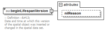 |
||||||||||||
| namespace | urn:x-inspire:specification:gmlas:AdministrativeUnits:3.0 | ||||||||||||
| type | extension of dateTime | ||||||||||||
| properties |
|
||||||||||||
| attributes |
|
||||||||||||
| annotation |
|
attribute AdministrativeUnitType/beginLifespanVersion/@nilReason
| type | gml:NilReasonType | ||
| properties |
|
element AdministrativeUnitType/endLifespanVersion
| diagram | 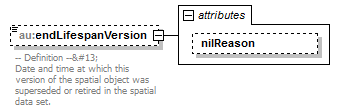 |
||||||||||||
| namespace | urn:x-inspire:specification:gmlas:AdministrativeUnits:3.0 | ||||||||||||
| type | extension of dateTime | ||||||||||||
| properties |
|
||||||||||||
| attributes |
|
||||||||||||
| annotation |
|
attribute AdministrativeUnitType/endLifespanVersion/@nilReason
| type | gml:NilReasonType | ||
| properties |
|
element AdministrativeUnitType/NUTS
| diagram | 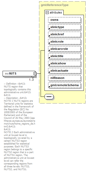 |
||||||||||||||||||||||||||||||||||||||||||||||||||||||||||||||||||||
| namespace | urn:x-inspire:specification:gmlas:AdministrativeUnits:3.0 | ||||||||||||||||||||||||||||||||||||||||||||||||||||||||||||||||||||
| type | gml:ReferenceType | ||||||||||||||||||||||||||||||||||||||||||||||||||||||||||||||||||||
| properties |
|
||||||||||||||||||||||||||||||||||||||||||||||||||||||||||||||||||||
| attributes |
|
||||||||||||||||||||||||||||||||||||||||||||||||||||||||||||||||||||
| annotation |
|
element AdministrativeUnitType/condominium
| diagram | 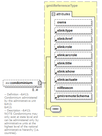 |
||||||||||||||||||||||||||||||||||||||||||||||||||||||||||||||||||||
| namespace | urn:x-inspire:specification:gmlas:AdministrativeUnits:3.0 | ||||||||||||||||||||||||||||||||||||||||||||||||||||||||||||||||||||
| type | gml:ReferenceType | ||||||||||||||||||||||||||||||||||||||||||||||||||||||||||||||||||||
| properties |
|
||||||||||||||||||||||||||||||||||||||||||||||||||||||||||||||||||||
| attributes |
|
||||||||||||||||||||||||||||||||||||||||||||||||||||||||||||||||||||
| annotation |
|
element AdministrativeUnitType/lowerLevelUnit
| diagram | 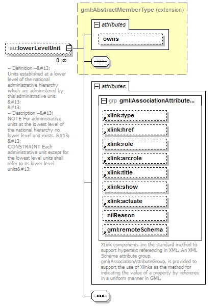 |
||||||||||||||||||||||||||||||||||||||||||||||||||||||||||||||||||||
| namespace | urn:x-inspire:specification:gmlas:AdministrativeUnits:3.0 | ||||||||||||||||||||||||||||||||||||||||||||||||||||||||||||||||||||
| type | extension of gml:AbstractMemberType | ||||||||||||||||||||||||||||||||||||||||||||||||||||||||||||||||||||
| properties |
|
||||||||||||||||||||||||||||||||||||||||||||||||||||||||||||||||||||
| attributes |
|
||||||||||||||||||||||||||||||||||||||||||||||||||||||||||||||||||||
| annotation |
|
element AdministrativeUnitType/upperLevelUnit
| diagram | 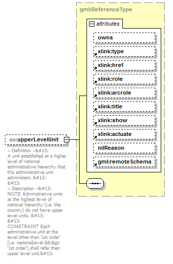 |
||||||||||||||||||||||||||||||||||||||||||||||||||||||||||||||||||||
| namespace | urn:x-inspire:specification:gmlas:AdministrativeUnits:3.0 | ||||||||||||||||||||||||||||||||||||||||||||||||||||||||||||||||||||
| type | gml:ReferenceType | ||||||||||||||||||||||||||||||||||||||||||||||||||||||||||||||||||||
| properties |
|
||||||||||||||||||||||||||||||||||||||||||||||||||||||||||||||||||||
| attributes |
|
||||||||||||||||||||||||||||||||||||||||||||||||||||||||||||||||||||
| annotation |
|
element AdministrativeUnitType/administeredBy
| diagram | 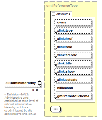 |
||||||||||||||||||||||||||||||||||||||||||||||||||||||||||||||||||||
| namespace | urn:x-inspire:specification:gmlas:AdministrativeUnits:3.0 | ||||||||||||||||||||||||||||||||||||||||||||||||||||||||||||||||||||
| type | gml:ReferenceType | ||||||||||||||||||||||||||||||||||||||||||||||||||||||||||||||||||||
| properties |
|
||||||||||||||||||||||||||||||||||||||||||||||||||||||||||||||||||||
| attributes |
|
||||||||||||||||||||||||||||||||||||||||||||||||||||||||||||||||||||
| annotation |
|
element AdministrativeUnitType/coAdminister
| diagram | 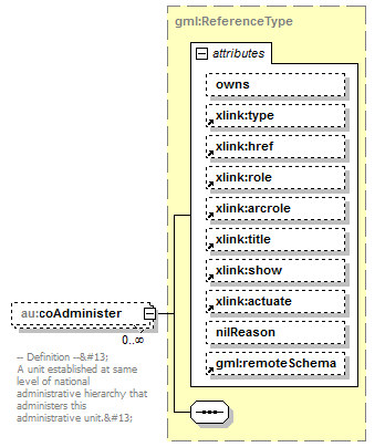 |
||||||||||||||||||||||||||||||||||||||||||||||||||||||||||||||||||||
| namespace | urn:x-inspire:specification:gmlas:AdministrativeUnits:3.0 | ||||||||||||||||||||||||||||||||||||||||||||||||||||||||||||||||||||
| type | gml:ReferenceType | ||||||||||||||||||||||||||||||||||||||||||||||||||||||||||||||||||||
| properties |
|
||||||||||||||||||||||||||||||||||||||||||||||||||||||||||||||||||||
| attributes |
|
||||||||||||||||||||||||||||||||||||||||||||||||||||||||||||||||||||
| annotation |
|
element AdministrativeUnitType/boundary
| diagram | 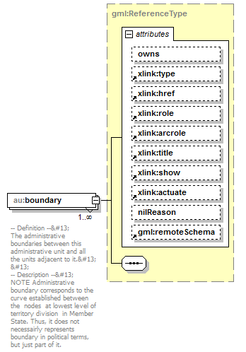 |
||||||||||||||||||||||||||||||||||||||||||||||||||||||||||||||||||||
| namespace | urn:x-inspire:specification:gmlas:AdministrativeUnits:3.0 | ||||||||||||||||||||||||||||||||||||||||||||||||||||||||||||||||||||
| type | gml:ReferenceType | ||||||||||||||||||||||||||||||||||||||||||||||||||||||||||||||||||||
| properties |
|
||||||||||||||||||||||||||||||||||||||||||||||||||||||||||||||||||||
| attributes |
|
||||||||||||||||||||||||||||||||||||||||||||||||||||||||||||||||||||
| annotation |
|
XML Schema documentation generated by XMLSpy Schema Editor http://www.altova.com/xmlspy