| diagram | 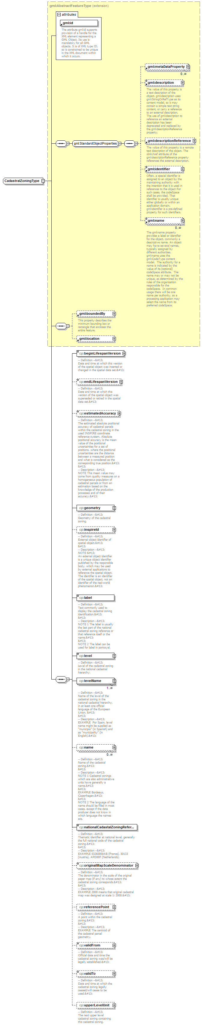 |
||||||||||||||
| namespace | urn:x-inspire:specification:gmlas:CadastralParcels:3.0 | ||||||||||||||
| type | extension of gml:AbstractFeatureType | ||||||||||||||
| properties |
|
||||||||||||||
| children | gml:metaDataProperty gml:description gml:descriptionReference gml:identifier gml:name gml:boundedBy gml:location cp:beginLifespanVersion cp:endLifespanVersion cp:estimatedAccuracy cp:geometry cp:inspireId cp:label cp:level cp:levelName cp:name cp:nationalCadastalZoningReference cp:originalMapScaleDenominator cp:referencePoint cp:validFrom cp:validTo cp:upperLevelUnit | ||||||||||||||
| attributes |
|
element CadastralZoningType/beginLifespanVersion
| diagram | 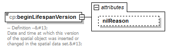 |
||||||||||||
| namespace | urn:x-inspire:specification:gmlas:CadastralParcels:3.0 | ||||||||||||
| type | extension of dateTime | ||||||||||||
| properties |
|
||||||||||||
| attributes |
|
||||||||||||
| annotation |
|
attribute CadastralZoningType/beginLifespanVersion/@nilReason
| type | gml:NilReasonType | ||
| properties |
|
element CadastralZoningType/endLifespanVersion
| diagram | 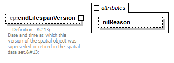 |
||||||||||||
| namespace | urn:x-inspire:specification:gmlas:CadastralParcels:3.0 | ||||||||||||
| type | extension of dateTime | ||||||||||||
| properties |
|
||||||||||||
| attributes |
|
||||||||||||
| annotation |
|
attribute CadastralZoningType/endLifespanVersion/@nilReason
| type | gml:NilReasonType | ||
| properties |
|
element CadastralZoningType/estimatedAccuracy
| diagram | 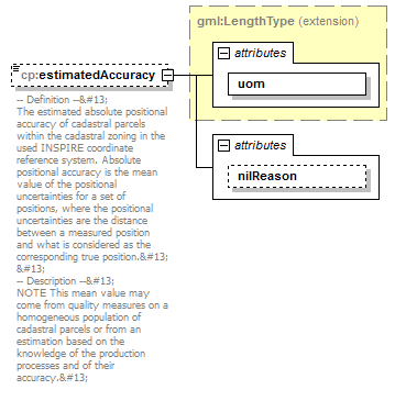 |
||||||||||||||||||
| namespace | urn:x-inspire:specification:gmlas:CadastralParcels:3.0 | ||||||||||||||||||
| type | extension of gml:LengthType | ||||||||||||||||||
| properties |
|
||||||||||||||||||
| attributes |
|
||||||||||||||||||
| annotation |
|
attribute CadastralZoningType/estimatedAccuracy/@nilReason
| type | gml:NilReasonType | ||
| properties |
|
element CadastralZoningType/geometry
| diagram | 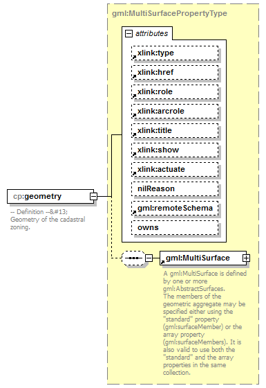 |
||||||||||||||||||||||||||||||||||||||||||||||||||||||||||||||||||||
| namespace | urn:x-inspire:specification:gmlas:CadastralParcels:3.0 | ||||||||||||||||||||||||||||||||||||||||||||||||||||||||||||||||||||
| type | gml:MultiSurfacePropertyType | ||||||||||||||||||||||||||||||||||||||||||||||||||||||||||||||||||||
| properties |
|
||||||||||||||||||||||||||||||||||||||||||||||||||||||||||||||||||||
| children | gml:MultiSurface | ||||||||||||||||||||||||||||||||||||||||||||||||||||||||||||||||||||
| attributes |
|
||||||||||||||||||||||||||||||||||||||||||||||||||||||||||||||||||||
| annotation |
|
element CadastralZoningType/inspireId
| diagram | 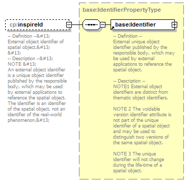 |
||||||||
| namespace | urn:x-inspire:specification:gmlas:CadastralParcels:3.0 | ||||||||
| type | base:IdentifierPropertyType | ||||||||
| properties |
|
||||||||
| children | base:Identifier | ||||||||
| annotation |
|
element CadastralZoningType/label
| diagram | 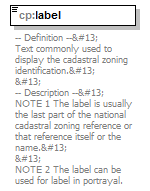 |
||||
| namespace | urn:x-inspire:specification:gmlas:CadastralParcels:3.0 | ||||
| type | string | ||||
| properties |
|
||||
| annotation |
|
element CadastralZoningType/level
| diagram |  |
||||||||||||||||||
| namespace | urn:x-inspire:specification:gmlas:CadastralParcels:3.0 | ||||||||||||||||||
| type | extension of gml:CodeType | ||||||||||||||||||
| properties |
|
||||||||||||||||||
| attributes |
|
||||||||||||||||||
| annotation |
|
attribute CadastralZoningType/level/@nilReason
| type | gml:NilReasonType | ||
| properties |
|
element CadastralZoningType/levelName
| diagram | 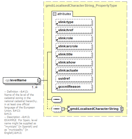 |
||||||||||||||||||||||||||||||||||||||||||||||||||||||||||||
| namespace | urn:x-inspire:specification:gmlas:CadastralParcels:3.0 | ||||||||||||||||||||||||||||||||||||||||||||||||||||||||||||
| type | gmd:LocalisedCharacterString_PropertyType | ||||||||||||||||||||||||||||||||||||||||||||||||||||||||||||
| properties |
|
||||||||||||||||||||||||||||||||||||||||||||||||||||||||||||
| children | gmd:LocalisedCharacterString | ||||||||||||||||||||||||||||||||||||||||||||||||||||||||||||
| attributes |
|
||||||||||||||||||||||||||||||||||||||||||||||||||||||||||||
| annotation |
|
element CadastralZoningType/name
| diagram | 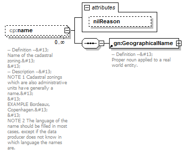 |
||||||||||||
| namespace | urn:x-inspire:specification:gmlas:CadastralParcels:3.0 | ||||||||||||
| properties |
|
||||||||||||
| children | gn:GeographicalName | ||||||||||||
| attributes |
|
||||||||||||
| annotation |
|
attribute CadastralZoningType/name/@nilReason
| type | gml:NilReasonType | ||
| properties |
|
element CadastralZoningType/nationalCadastalZoningReference
| diagram | 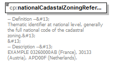 |
||||
| namespace | urn:x-inspire:specification:gmlas:CadastralParcels:3.0 | ||||
| type | string | ||||
| properties |
|
||||
| annotation |
|
element CadastralZoningType/originalMapScaleDenominator
| diagram | 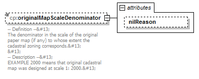 |
||||||||||||
| namespace | urn:x-inspire:specification:gmlas:CadastralParcels:3.0 | ||||||||||||
| type | extension of integer | ||||||||||||
| properties |
|
||||||||||||
| attributes |
|
||||||||||||
| annotation |
|
attribute CadastralZoningType/originalMapScaleDenominator/@nilReason
| type | gml:NilReasonType | ||
| properties |
|
element CadastralZoningType/referencePoint
| diagram | 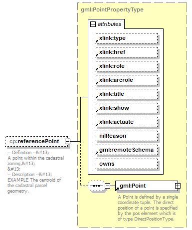 |
||||||||||||||||||||||||||||||||||||||||||||||||||||||||||||||||||||
| namespace | urn:x-inspire:specification:gmlas:CadastralParcels:3.0 | ||||||||||||||||||||||||||||||||||||||||||||||||||||||||||||||||||||
| type | gml:PointPropertyType | ||||||||||||||||||||||||||||||||||||||||||||||||||||||||||||||||||||
| properties |
|
||||||||||||||||||||||||||||||||||||||||||||||||||||||||||||||||||||
| children | gml:Point | ||||||||||||||||||||||||||||||||||||||||||||||||||||||||||||||||||||
| attributes |
|
||||||||||||||||||||||||||||||||||||||||||||||||||||||||||||||||||||
| annotation |
|
element CadastralZoningType/validFrom
| diagram | 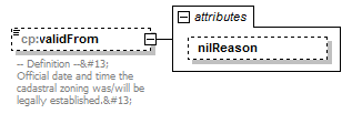 |
||||||||||||
| namespace | urn:x-inspire:specification:gmlas:CadastralParcels:3.0 | ||||||||||||
| type | extension of dateTime | ||||||||||||
| properties |
|
||||||||||||
| attributes |
|
||||||||||||
| annotation |
|
attribute CadastralZoningType/validFrom/@nilReason
| type | gml:NilReasonType | ||
| properties |
|
element CadastralZoningType/validTo
| diagram | 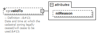 |
||||||||||||
| namespace | urn:x-inspire:specification:gmlas:CadastralParcels:3.0 | ||||||||||||
| type | extension of dateTime | ||||||||||||
| properties |
|
||||||||||||
| attributes |
|
||||||||||||
| annotation |
|
attribute CadastralZoningType/validTo/@nilReason
| type | gml:NilReasonType | ||
| properties |
|
element CadastralZoningType/upperLevelUnit
| diagram | 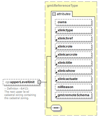 |
||||||||||||||||||||||||||||||||||||||||||||||||||||||||||||||||||||
| namespace | urn:x-inspire:specification:gmlas:CadastralParcels:3.0 | ||||||||||||||||||||||||||||||||||||||||||||||||||||||||||||||||||||
| type | gml:ReferenceType | ||||||||||||||||||||||||||||||||||||||||||||||||||||||||||||||||||||
| properties |
|
||||||||||||||||||||||||||||||||||||||||||||||||||||||||||||||||||||
| attributes |
|
||||||||||||||||||||||||||||||||||||||||||||||||||||||||||||||||||||
| annotation |
|
XML Schema documentation generated by XMLSpy Schema Editor http://www.altova.com/xmlspy