complexType NamedPlaceType
diagram AirQualityReporting_p749.png
namespace urn:x-inspire:specification:gmlas:GeographicalNames:3.0
type extension of gml:AbstractFeatureType
properties
base gml:AbstractFeatureType
children gml:metaDataProperty gml:description gml:descriptionReference gml:identifier gml:name gml:boundedBy gml:location gn:beginLifespanVersion gn:endLifespanVersion gn:geometry gn:inspireId gn:leastDetailedViewingResolution gn:localType gn:mostDetailedViewingResolution gn:name gn:relatedSpatialObject gn:type
attributes
Name  Type  Use  Default  Fixed  annotation
idrequired      
documentation
The attribute gml:id supports provision of a handle for the XML element representing a GML Object. Its use is mandatory for all GML objects. It is of XML type ID, so is constrained to be unique in the XML document within which it occurs.

element NamedPlaceType/beginLifespanVersion
diagram AirQualityReporting_p750.png
namespace urn:x-inspire:specification:gmlas:GeographicalNames:3.0
type extension of dateTime
properties
isRef 0
content complex
nillable true
attributes
Name  Type  Use  Default  Fixed  annotation
nilReasongml:NilReasonType      
annotation
documentation
-- Definition --
Date and time at which this version of the spatial object was inserted or changed in the spatial data set.

attribute NamedPlaceType/beginLifespanVersion/@nilReason
type gml:NilReasonType
properties
isRef 0

element NamedPlaceType/endLifespanVersion
diagram AirQualityReporting_p751.png
namespace urn:x-inspire:specification:gmlas:GeographicalNames:3.0
type extension of dateTime
properties
isRef 0
minOcc 0
maxOcc 1
content complex
nillable true
attributes
Name  Type  Use  Default  Fixed  annotation
nilReasongml:NilReasonType      
annotation
documentation
-- Definition --
Date and time at which this version of the spatial object was superseded or retired in the spatial data set.

attribute NamedPlaceType/endLifespanVersion/@nilReason
type gml:NilReasonType
properties
isRef 0

element NamedPlaceType/geometry
diagram AirQualityReporting_p752.png
namespace urn:x-inspire:specification:gmlas:GeographicalNames:3.0
type gml:GeometryPropertyType
properties
isRef 0
content complex
children gml:AbstractGeometry
attributes
Name  Type  Use  Default  Fixed  annotation
type    simple  
href      
role      
arcrole      
title      
show      
actuate      
nilReasongml:NilReasonType      
remoteSchema      
appinfo
deprecated
ownsboolean  false    
annotation
documentation
-- Definition --
Geometry associated to the named place. This data specification does not restrict the geometry types. 

-- Description --
NOTE 1 The most common geometry types for a named place are a reference point (modelled as GM_Point), a more precise geometry of the footprint (typically modelled as GM_Curve or GM_Surface), or a bounding box (to be modelled as a GM_Envelope).

NOTE 2 If the geometry depicts the spatial footprint of the named place, a reference point and a bounding box could be derived from it. However, this specification does not require the explicit provision of any specific type of geometry such as bounding boxes or reference points.

NOTE 3 To avoid any misunderstanding, note that null geometry is not allowed by this specification.

NOTE 4 3D geometries are not really required for Geographical Names, but the model allows for it, so a data provider may publish it.

element NamedPlaceType/inspireId
diagram AirQualityReporting_p753.png
namespace urn:x-inspire:specification:gmlas:GeographicalNames:3.0
type base:IdentifierPropertyType
properties
isRef 0
content complex
children base:Identifier
annotation
documentation
-- Definition --
External object identifier of the spatial object.

-- Description --
NOTE An external object identifier is a unique object identifier published by the responsible body, which may be used by external applications to reference the spatial object. The identifier is an identifier of the spatial object, not an identifier of the real-world phenomenon.

element NamedPlaceType/leastDetailedViewingResolution
diagram AirQualityReporting_p754.png
namespace urn:x-inspire:specification:gmlas:GeographicalNames:3.0
type extension of gml:AbstractMetadataPropertyType
properties
isRef 0
minOcc 0
maxOcc 1
content complex
nillable true
children gmd:MD_Resolution
attributes
Name  Type  Use  Default  Fixed  annotation
ownsboolean  false    
nilReasongml:NilReasonType      
annotation
documentation
-- Definition --
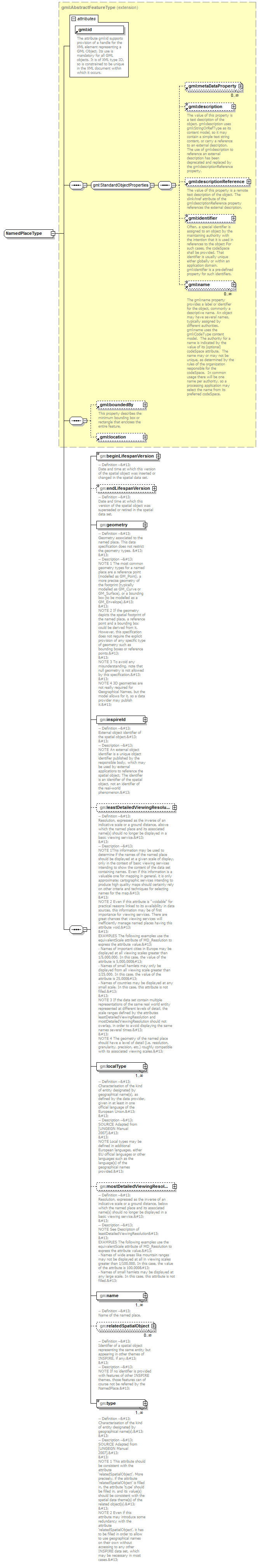
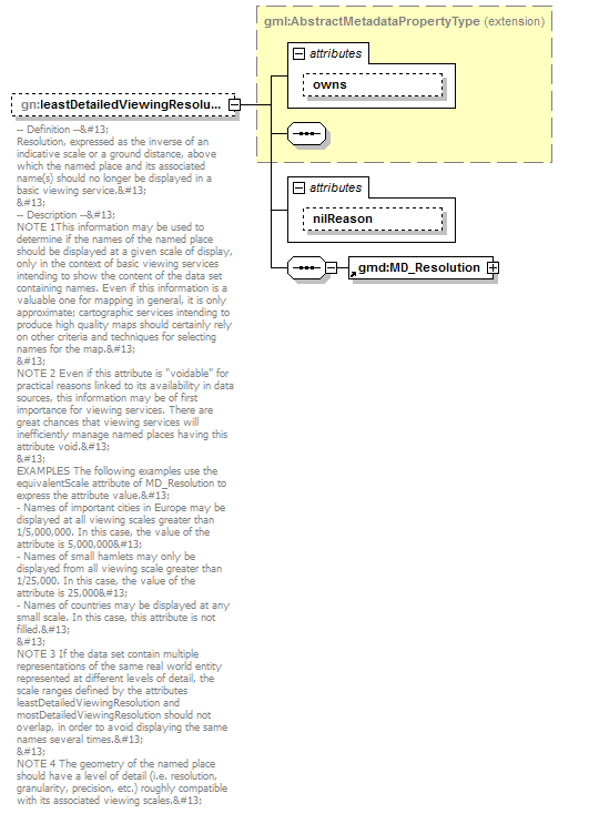
Resolution, expressed as the inverse of an indicative scale or a ground distance, above which the named place and its associated name(s) should no longer be displayed in a basic viewing service.

-- Description --
NOTE 1This information may be used to determine if the names of the named place should be displayed at a given scale of display, only in the context of basic viewing services intending to show the content of the data set containing names. Even if this information is a valuable one for mapping in general, it is only approximate; cartographic services intending to produce high quality maps should certainly rely on other criteria and techniques for selecting names for the map.

NOTE 2 Even if this attribute is "voidable" for practical reasons linked to its availability in data sources, this information may be of first importance for viewing services. There are great chances that viewing services will inefficiently manage named places having this attribute void.

EXAMPLES The following examples use the equivalentScale attribute of MD_Resolution to express the attribute value.
- Names of important cities in Europe may be displayed at all viewing scales greater than 1/5,000,000. In this case, the value of the attribute is 5,000,000
- Names of small hamlets may only be displayed from all viewing scale greater than 1/25,000. In this case, the value of the attribute is 25,000
- Names of countries may be displayed at any small scale. In this case, this attribute is not filled.

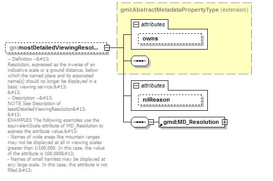
NOTE 3 If the data set contain multiple representations of the same real world entity represented at different levels of detail, the scale ranges defined by the attributes leastDetailedViewingResolution and mostDetailedViewingResolution should not overlap, in order to avoid displaying the same names several times.

NOTE 4 The geometry of the named place should have a level of detail (i.e. resolution, granularity, precision, etc.) roughly compatible with its associated viewing scales.

attribute NamedPlaceType/leastDetailedViewingResolution/@nilReason
type gml:NilReasonType
properties
isRef 0

element NamedPlaceType/localType
diagram AirQualityReporting_p755.png
namespace urn:x-inspire:specification:gmlas:GeographicalNames:3.0
type gmd:LocalisedCharacterString_PropertyType
properties
isRef 0
minOcc 1
maxOcc unbounded
content complex
nillable true
children gmd:LocalisedCharacterString
attributes
Name  Type  Use  Default  Fixed  annotation
type    simple  
href      
role      
arcrole      
title      
show      
actuate      
uuidrefstring      
nilReason      
annotation
documentation
-- Definition --
Characterisation of the kind of entity designated by geographical name(s), as defined by the data provider, given in at least in one official language of the European Union.

-- Description --
SOURCE Adapted from [UNGEGN Manual 2007].

NOTE Local types may be defined in additional European languages, either EU official languages or other languages such as the language(s) of the geographical names provided.

element NamedPlaceType/mostDetailedViewingResolution
diagram AirQualityReporting_p756.png
namespace urn:x-inspire:specification:gmlas:GeographicalNames:3.0
type extension of gml:AbstractMetadataPropertyType
properties
isRef 0
minOcc 0
maxOcc 1
content complex
nillable true
children gmd:MD_Resolution
attributes
Name  Type  Use  Default  Fixed  annotation
ownsboolean  false    
nilReasongml:NilReasonType      
annotation
documentation
-- Definition --
Resolution, expressed as the inverse of an indicative scale or a ground distance, below which the named place and its associated name(s) should no longer be displayed in a basic viewing service.

-- Description --
NOTE See Description of leastDetailedViewingResolution

EXAMPLES The following examples use the equivalentScale attribute of MD_Resolution to express the attribute value.
- Names of wide areas like mountain ranges may not be displayed at all in viewing scales greater than 1/100,000. In this case, the value of the attribute is 100,000
- Names of small hamlets may be displayed at any large scale. In this case, this attribute is not filled.

attribute NamedPlaceType/mostDetailedViewingResolution/@nilReason
type gml:NilReasonType
properties
isRef 0

element NamedPlaceType/name
diagram AirQualityReporting_p757.png
namespace urn:x-inspire:specification:gmlas:GeographicalNames:3.0
type gn:GeographicalNamePropertyType
properties
isRef 0
minOcc 1
maxOcc unbounded
content complex
children gn:GeographicalName
annotation
documentation
-- Definition --
Name of the named place.

element NamedPlaceType/relatedSpatialObject
diagram AirQualityReporting_p758.png
namespace urn:x-inspire:specification:gmlas:GeographicalNames:3.0
properties
isRef 0
minOcc 0
maxOcc unbounded
content complex
nillable true
children base:Identifier
attributes
Name  Type  Use  Default  Fixed  annotation
nilReasongml:NilReasonType      
annotation
documentation
-- Definition --
Identifier of a spatial object representing the same entity but appearing in other themes of INSPIRE, if any.

-- Description --
NOTE If no identifier is provided with features of other INSPIRE themes, those features can of course not be referred by the NamedPlace.

attribute NamedPlaceType/relatedSpatialObject/@nilReason
type gml:NilReasonType
properties
isRef 0

element NamedPlaceType/type
diagram AirQualityReporting_p759.png
namespace urn:x-inspire:specification:gmlas:GeographicalNames:3.0
type extension of gml:CodeType
properties
isRef 0
minOcc 1
maxOcc unbounded
content complex
nillable true
attributes
Name  Type  Use  Default  Fixed  annotation
codeSpaceanyURI      
nilReasongml:NilReasonType      
annotation
documentation
-- Definition --
Characterisation of the kind of entity designated by geographical name(s).

-- Description --
SOURCE Adapted from [UNGEGN Manual 2007].

NOTE 1 This attribute should be consistent with the attribute 'relatedSpatialObject'. More precisely, if the attribute 'relatedSpatialObject' is filled in, the attribute 'type' should be filled in, and its value(s) should be consistent with the spatial data theme(s) of the related object(s).

NOTE 2 Even if this attribute may introduce some redundancy with the attribute 'relatedSpatialObject', it has to be filled in order to allow to use geographical names on their own without accessing to any other INSPIRE data set, which may be necessary in most cases.

attribute NamedPlaceType/type/@nilReason
type gml:NilReasonType
properties
isRef 0


XML Schema documentation generated by XMLSpy Schema Editor http://www.altova.com/xmlspy